-
Class E airspace from the surface to 1,200 feet MSL.
-
Class D airspace from the surface to the floor of the overlying Class E airspace.
-
Class G airspace from the surface up to but not including 700 feet AGL.
UAV CampusAdministrator
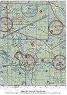
The airspace overlying and within miles of Barnes County Airport is (Area 5)
Share


Class G airspace from the surface up to but not including 700 feet AGL.
As shown in the attached figure, Barnes County Airport (BAC) is enclosed by a shaded magenta area, indicating Class E airspace starting at 700 feet AGL. This means the airspace is Class G from the surface up to 699 feet AGL, and Class E from 700 feet AGL up to the next underlying airspace, Class A, which begins at 18,000 feet MSL. For more details, refer to the “Class E: Definitions” video.