Sign Up

Sign Up to our FAA Prep for the Remote Pilot Exam. Ask questions, answer people’s questions, and connect with other UAV/Drone Pilots.

Have an account? Sign In

Have an account? Sign In Now

Sign In

Login to our social questions & Answers Engine to ask questions answer people’s questions & connect with other people.

Sign Up Here

Forgot Password?

Don't have account, Sign Up Here

Forgot Password

Lost your password? Please enter your email address. You will receive a link and will create a new password via email.

Have an account? Sign In Now

You must login to ask a question.

Forgot Password?

Need An Account, Sign Up Here

Please briefly explain why you feel this question should be reported.

Please briefly explain why you feel this answer should be reported.

Please briefly explain why you feel this user should be reported.

Sign InSign Up

UAV Campus | Remote Pilot FAA Exam Prep for Drones

UAV Campus | Remote Pilot FAA Exam Prep for Drones Logo UAV Campus | Remote Pilot FAA Exam Prep for Drones Logo
Search
Ask A Question

Mobile menu

Close
Ask A Question
  • Home
  • About Us
  • Blog
  • Contact Us

Identify the airspace over Bryn Airport. (Area 2)

Home/ Questions/Q 1386
Next
Answered

UAV Campus | Remote Pilot FAA Exam Prep for Drones Latest Questions

UAV Campus
  • 0
  • 0
UAV CampusAdministrator
Asked: August 4, 20242024-08-04T22:58:59+00:00 2024-08-04T22:58:59+00:00In: Navigating Charts

Identify the airspace over Bryn Airport. (Area 2)

  • 0
  • 0
Identify the airspace over Bryn Airport. (Area 2)
  1. Class G airspace — surface up to but not including 700 feet MSL; Class E airspace — 700 feet to 14,500 feet MSL.
  2. Class G airspace — surface up to but not including 18,000 feet MSL.
  3. Class G airspace — surface up to but not including 1,200 feet AGL; Class E airspace — 1,200 feet AGL up to but not including 18,000 feet MSL.
charts
  • 1 1 Answer
  • 307 Views
  • 0 Followers
  • 0
Share
  • Facebook
  • Report
Leave an answer

Leave an answer
Cancel reply

Browse

1 Answer

  • Voted
  • Oldest
  • Recent
  1. UAV Campus
    Best Answer
    UAV Campus Administrator
    2024-08-04T23:00:04+00:00Added an answer on August 4, 2024 at 11:00 pm
    Identify the airspace over Bryn Airport. (Area 2)

    Class G airspace — surface up to but not including 1,200 feet AGL; Class E airspace — 1,200 feet AGL up to but not including 18,000 feet MSL.


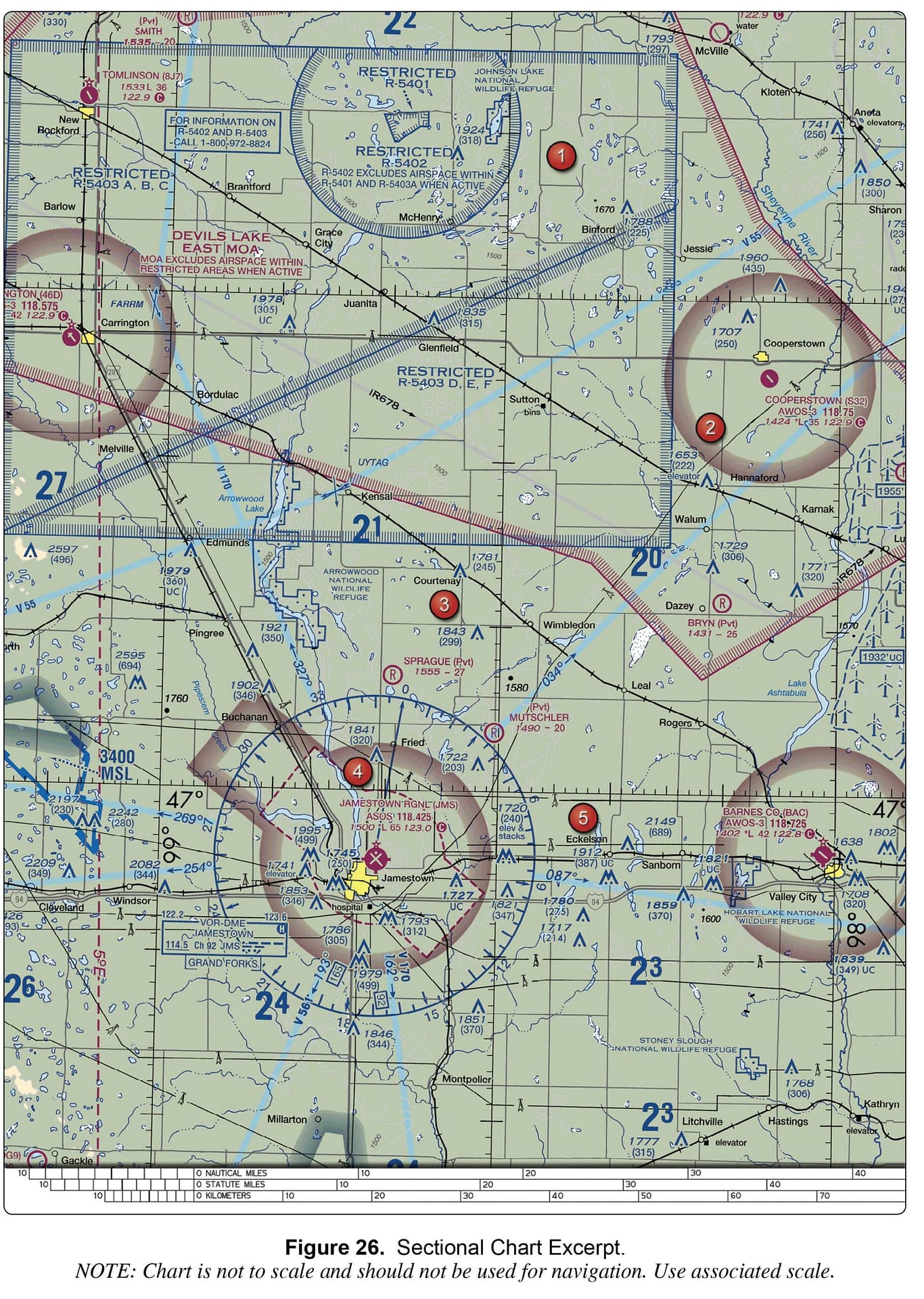
    As shown in the attached figure, Bryn Airport (a private airport) is located within a Military Operating Area and near a Restricted Area (see the larger figure from the question). The absence of other airspace markings indicates that Bryn is surrounded by Class G airspace, which is common for many private airports. Additionally, we know that in the US, Class E airspace begins at 1,200 feet AGL (not depicted). Therefore, in this case, the airspace is Class G from the surface to 1,199 feet AGL and then Class E from 1,200 feet AGL up to the next underlying airspace, Class A, at 18,000 feet MSL. For more details, refer to the “Class E: Definitions” and “Class G” videos.

      • 0
    • Reply
    • Share
      Share
      • Share on Facebook
      • Share on Twitter
      • Share on LinkedIn
      • Share on WhatsApp
      • Report

Related Questions

  • Why would the small flag at Lake Drummond in area of the sectional chart be important to a remote PIC?
  • At Sioux Gateway/Col Day (N42°20.67' W96°19.42'), which frequency should be used as a Common Traffic Advisory Frequency (CTAF) to self-announce ...
  • Sky Way Airport is (Area 6)
  • Dubey Airport is (Area 1)
  • What kind of airport is Deshler (6D7)? (Area 2)

Sidebar

Ask A Question

Stats

  • Questions 315
  • Answers 314
  • Best Answers 314
  • Users 156
  • Most visited
  • UAV Campus

    What hazards to aircraft may exist in areas such as ...

    • 1 Answer
  • UAV Campus

    As temperature decreases, aircraft performance will

    • 1 Answer
  • UAV Campus

    The correct method of stating 10,500 feet MSL to ATC ...

    • 1 Answer
  • UAV Campus

    A military air station can be identified by a rotating ...

    • 1 Answer
  • UAV Campus

    At Sioux Gateway/Col Day (N42°20.67' W96°19.42'), which frequency should be ...

    • 1 Answer

Categories

FAA Regulation
Understanding Weather
Understanding Airspace
UAV Loading and Performance
Navigating Charts
Airport Operations
Weather Service Dynamics
Aeronautical Decision Making (ADM)
Night Operations
Pilot Physiological Factors
Maintenance & Inspection Fundamentals
Aviation Radio Communications

Footer

UAV Campus | Remote Pilot FAA Exam Prep for Drones

UAVCampus.com provides this FAA Prep at no charge to all students and visitors. If you have a question about something on our test prep please contact us.

About Us

Legal Stuff

Help

Follow

© 2024 UAVCampus.com All Rights Reserved

Insert/edit link

Enter the destination URL

Or link to existing content

    No search term specified. Showing recent items. Search or use up and down arrow keys to select an item.