Sign Up

Sign Up to our FAA Prep for the Remote Pilot Exam. Ask questions, answer people’s questions, and connect with other UAV/Drone Pilots.

Have an account? Sign In

Have an account? Sign In Now

Sign In

Login to our social questions & Answers Engine to ask questions answer people’s questions & connect with other people.

Sign Up Here

Forgot Password?

Don't have account, Sign Up Here

Forgot Password

Lost your password? Please enter your email address. You will receive a link and will create a new password via email.

Have an account? Sign In Now

You must login to ask a question.

Forgot Password?

Need An Account, Sign Up Here

Please briefly explain why you feel this question should be reported.

Please briefly explain why you feel this answer should be reported.

Please briefly explain why you feel this user should be reported.

Sign InSign Up

UAV Campus | Remote Pilot FAA Exam Prep for Drones

UAV Campus | Remote Pilot FAA Exam Prep for Drones Logo UAV Campus | Remote Pilot FAA Exam Prep for Drones Logo
Search
Ask A Question

Mobile menu

Close
Ask A Question
  • Home
  • About Us
  • Blog
  • Contact Us

Share & Grow as an FAA Certified Remote Pilot!

We want to connect you and others around the U.S. to the best FAA Remote Pilot Exam Prep. We have developed some of the best online courses that are affordable for everyone to participate in and learn from. Plus we have created this amazing Quizlet style Q&A to help you prepare for the FAA exam!

Create A New Account
  • Recent Questions
  • Most Answered
  • Answers
  • Most Visited
  • Most Voted
  • No Answers
  1. Asked: August 4, 2024In: Navigating Charts

    For information about the parachute jumping at Caddo Mills Airport (Area 1) refer to

    UAV Campus
    Best Answer
    UAV Campus Administrator
    Added an answer on August 4, 2024 at 11:01 pm

    the Airport/Facility Directory section of the Chart Supplement.

    the Airport/Facility Directory section of the Chart Supplement.

    See less
      • 0
    • Share
      Share
      • Share on Facebook
      • Share on Twitter
      • Share on LinkedIn
      • Share on WhatsApp
      • Report
  2. Asked: August 4, 2024In: Navigating Charts

    Identify the airspace over Bryn Airport. (Area 2)

    UAV Campus
    Best Answer
    UAV Campus Administrator
    Added an answer on August 4, 2024 at 11:00 pm
    Home

    Class G airspace -- surface up to but not including 1,200 feet AGL; Class E airspace -- 1,200 feet AGL up to but not including 18,000 feet MSL.   As shown in the attached figure, Bryn Airport (a private airport) is located within a Military Operating Area and near a Restricted Area (see the larRead more

    Class G airspace — surface up to but not including 1,200 feet AGL; Class E airspace — 1,200 feet AGL up to but not including 18,000 feet MSL.


    As shown in the attached figure, Bryn Airport (a private airport) is located within a Military Operating Area and near a Restricted Area (see the larger figure from the question). The absence of other airspace markings indicates that Bryn is surrounded by Class G airspace, which is common for many private airports. Additionally, we know that in the US, Class E airspace begins at 1,200 feet AGL (not depicted). Therefore, in this case, the airspace is Class G from the surface to 1,199 feet AGL and then Class E from 1,200 feet AGL up to the next underlying airspace, Class A, at 18,000 feet MSL. For more details, refer to the “Class E: Definitions” and “Class G” videos.

    See less
      • 0
    • Share
      Share
      • Share on Facebook
      • Share on Twitter
      • Share on LinkedIn
      • Share on WhatsApp
      • Report
  3. Asked: August 4, 2024In: Navigating Charts

    What is the airspace classification around Findlay (FDY) airport?

    UAV Campus
    Best Answer
    UAV Campus Administrator
    Added an answer on August 4, 2024 at 10:58 pm
    Home

    Class E.   FDY is depicted with a dashed magenta line and a solid magenta line, indicating Class E airspace starting at the surface and Class E airspace starting at 700 feet around the larger circle. For more information, refer to the "Class E: Skyvector" videos.

    Class E.


    FDY is depicted with a dashed magenta line and a solid magenta line, indicating Class E airspace starting at the surface and Class E airspace starting at 700 feet around the larger circle. For more information, refer to the “Class E: Skyvector” videos.
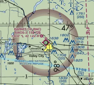
    See less
      • 0
    • Share
      Share
      • Share on Facebook
      • Share on Twitter
      • Share on LinkedIn
      • Share on WhatsApp
      • Report
  4. Asked: August 4, 2024In: Navigating Charts

    The airspace overlying and within miles of Barnes County Airport is (Area 5)

    UAV Campus
    Best Answer
    UAV Campus Administrator
    Added an answer on August 4, 2024 at 10:55 pm

    Class G airspace from the surface up to but not including 700 feet AGL.   As shown in the attached figure, Barnes County Airport (BAC) is enclosed by a shaded magenta area, indicating Class E airspace starting at 700 feet AGL. This means the airspace is Class G from the surface up to 699 feet ARead more

    Class G airspace from the surface up to but not including 700 feet AGL.


    As shown in the attached figure, Barnes County Airport (BAC) is enclosed by a shaded magenta area, indicating Class E airspace starting at 700 feet AGL. This means the airspace is Class G from the surface up to 699 feet AGL, and Class E from 700 feet AGL up to the next underlying airspace, Class A, which begins at 18,000 feet MSL. For more details, refer to the “Class E: Definitions” video.

    See less
      • 0
    • Share
      Share
      • Share on Facebook
      • Share on Twitter
      • Share on LinkedIn
      • Share on WhatsApp
      • Report
  5. Asked: August 4, 2024In: Navigating Charts

    The NALF Fentress (NFE) Airport is in what type of airspace? (Area 1)

    UAV Campus
    Best Answer
    UAV Campus Administrator
    Added an answer on August 4, 2024 at 10:53 pm

    Class E.   As shown in this figure, NALF is located within Class E airspace that begins at the surface, indicated by the dashed magenta line. For more details, see the "Class E: Definitions" video.

    Class E.


    As shown in this figure, NALF is located within Class E airspace that begins at the surface, indicated by the dashed magenta line. For more details, see the “Class E: Definitions” video.

    See less
      • 0
    • Share
      Share
      • Share on Facebook
      • Share on Twitter
      • Share on LinkedIn
      • Share on WhatsApp
      • Report
  6. Asked: August 4, 2024In: Navigating Charts

    The airspace directly overlying Fort Worth Meacham is (Area 4)

    UAV Campus
    Best Answer
    UAV Campus Administrator
    Added an answer on August 4, 2024 at 10:40 pm
    Home

    Class D airspace to 3,200 feet MSL.   Fort Worth Meacham (FTW) is enclosed by a dashed blue line, indicating Class D airspace. The number "32" shows that this airspace extends from the surface up to 3,200 feet MSL, as depicted in the figure below. For more details, refer to the "Class D: SkyvecRead more

    Class D airspace to 3,200 feet MSL.


    Fort Worth Meacham (FTW) is enclosed by a dashed blue line, indicating Class D airspace. The number “32” shows that this airspace extends from the surface up to 3,200 feet MSL, as depicted in the figure below. For more details, refer to the “Class D: Skyvector” video.

    See less
      • 0
    • Share
      Share
      • Share on Facebook
      • Share on Twitter
      • Share on LinkedIn
      • Share on WhatsApp
      • Report
  7. Asked: August 4, 2024In: Navigating Charts

    The airspace surrounding the Gila Bend AF AUX Airport (GXF) (area 6) is classified as Class

    UAV Campus
    Best Answer
    UAV Campus Administrator
    Added an answer on August 4, 2024 at 10:38 pm

    Class D.   The dashed blue line represents Class D airspace, as illustrated in the figures below. For additional information, see the "Class D: Definitions" video.  

    Class D.


    The dashed blue line represents Class D airspace, as illustrated in the figures below. For additional information, see the “Class D: Definitions” video.


    See less
      • 0
    • Share
      Share
      • Share on Facebook
      • Share on Twitter
      • Share on LinkedIn
      • Share on WhatsApp
      • Report
Load More Answers

Sidebar

Ask A Question

Stats

  • Questions 314
  • Answers 314
  • Best Answers 314
  • Users 165
  • Most visited
  • UAV Campus

    What hazards to aircraft may exist in areas such as ...

    • 1 Answer
  • UAV Campus

    As temperature decreases, aircraft performance will

    • 1 Answer
  • UAV Campus

    The correct method of stating 10,500 feet MSL to ATC ...

    • 1 Answer
  • UAV Campus

    You hire a German company to help you work on ...

    • 1 Answer
  • UAV Campus

    A military air station can be identified by a rotating ...

    • 1 Answer

Categories

FAA Regulation
Understanding Weather
Understanding Airspace
UAV Loading and Performance
Navigating Charts
Airport Operations
Weather Service Dynamics
Aeronautical Decision Making (ADM)
Night Operations
Pilot Physiological Factors
Maintenance & Inspection Fundamentals
Aviation Radio Communications

Footer

UAV Campus | Remote Pilot FAA Exam Prep for Drones

UAVCampus.com provides this FAA Prep at no charge to all students and visitors. If you have a question about something on our test prep please contact us.

About Us

Legal Stuff

Help

Follow

© 2024 UAVCampus.com All Rights Reserved