Sign Up

Sign Up to our FAA Prep for the Remote Pilot Exam. Ask questions, answer people’s questions, and connect with other UAV/Drone Pilots.

Have an account? Sign In

Have an account? Sign In Now

Sign In

Login to our social questions & Answers Engine to ask questions answer people’s questions & connect with other people.

Sign Up Here

Forgot Password?

Don't have account, Sign Up Here

Forgot Password

Lost your password? Please enter your email address. You will receive a link and will create a new password via email.

Have an account? Sign In Now

You must login to ask a question.

Forgot Password?

Need An Account, Sign Up Here

Please briefly explain why you feel this question should be reported.

Please briefly explain why you feel this answer should be reported.

Please briefly explain why you feel this user should be reported.

Sign InSign Up

UAV Campus | Remote Pilot FAA Exam Prep for Drones

UAV Campus | Remote Pilot FAA Exam Prep for Drones Logo UAV Campus | Remote Pilot FAA Exam Prep for Drones Logo
Search
Ask A Question

Mobile menu

Close
Ask A Question
  • Home
  • About Us
  • Blog
  • Contact Us

Share & Grow as an FAA Certified Remote Pilot!

We want to connect you and others around the U.S. to the best FAA Remote Pilot Exam Prep. We have developed some of the best online courses that are affordable for everyone to participate in and learn from. Plus we have created this amazing Quizlet style Q&A to help you prepare for the FAA exam!

Create A New Account
  • Recent Questions
  • Most Answered
  • Answers
  • Most Visited
  • Most Voted
  • No Answers
UAV Campus
  • 0
UAV CampusAdministrator
Asked: August 4, 2024In: Weather Service Dynamics

Automatic Terminal Information Service (ATIS) is the continuous broadcast of recorded information concerning

  • 0

nonessential information to reduce frequency congestion. pilots of radar-identified aircraft whose aircraft is in dangerous proximity to terrain or to an obstruction. non control information in selected high-activity terminal areas.

weather services 1
  • 1 Answer
  • 269 Views
Answer
UAV Campus
  • 0
UAV CampusAdministrator
Asked: August 4, 2024In: Navigating Charts

Why would the small flag at Lake Drummond in area of the sectional chart be important to a remote PIC?

  • 0

  The flag indicates that there will be a large obstruction depicted on ...

charts
  • 1 Answer
  • 303 Views
Answer
UAV Campus
  • 0
UAV CampusAdministrator
Asked: August 4, 2024In: Navigating Charts

At Sioux Gateway/Col Day (N42°20.67' W96°19.42'), which frequency should be used as a Common Traffic Advisory Frequency (CTAF) to self-announce position and intentions when the control tower is closed?

  • 0
At Sioux Gateway/Col Day (N42°20.67' W96°19.42'), which frequency should be used as a Common Traffic Advisory Frequency (CTAF) to self-announce position and intentions when the control tower is closed?

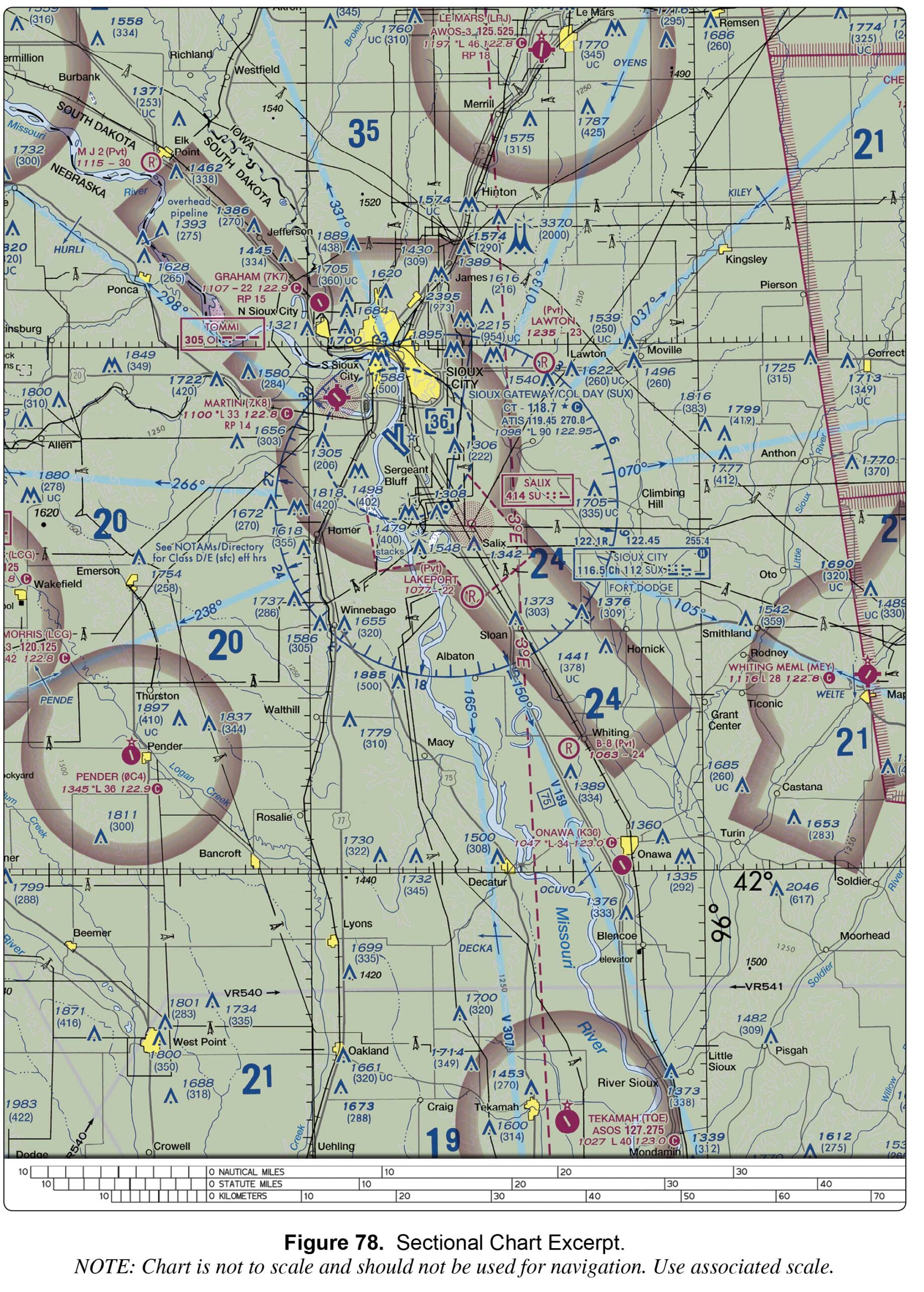
122.95 MHz. 118.7 MHz. 119.45 MHz.

charts
  • 1 Answer
  • 433 Views
Answer
UAV Campus
  • 0
UAV CampusAdministrator
Asked: August 4, 2024In: Navigating Charts

Sky Way Airport is (Area 6)

  • 0

a nonpublic-use airport. an airport restricted to use by private and recreational pilots. a restricted ...

charts
  • 1 Answer
  • 299 Views
Answer
UAV Campus
  • 0
UAV CampusAdministrator
Asked: August 4, 2024In: Navigating Charts

Dubey Airport is (Area 1)

  • 0
Dubey Airport is (Area 1)

a privately owned airport restricted to use. an airport restricted to use by sport pilots only. a restricted military stage field within restricted airspace.

charts
  • 1 Answer
  • 302 Views
Answer
UAV Campus
  • 0
UAV CampusAdministrator
Asked: August 4, 2024In: Navigating Charts

What kind of airport is Deshler (6D7)? (Area 2)

  • 0
What kind of airport is Deshler (6D7)? (Area 2)

A private airport with a grass runway. An abandoned paved airport having landmark value. A public airport with a runway that is not a hard surface.

charts
  • 1 Answer
  • 353 Views
Answer
UAV Campus
  • 0
UAV CampusAdministrator
Asked: August 4, 2024In: Navigating Charts

Which is true concerning the blue and magenta colors used to depict airports on Sectional Aeronautical Charts?

  • 0

Airports with control towers underlying Class C, D, and E airspace are shown in magenta. Airports with control towers underlying Class B, C, D, and E airspace are shown in blue. Airports with control towers underlying Class A, B, and ...

charts
  • 1 Answer
  • 56 Views
Answer
Load More Questions

Sidebar

Ask A Question

Stats

  • Questions 314
  • Answers 314
  • Best Answers 314
  • Users 165
  • Most visited
  • UAV Campus

    What hazards to aircraft may exist in areas such as ...

    • 1 Answer
  • UAV Campus

    As temperature decreases, aircraft performance will

    • 1 Answer
  • UAV Campus

    The correct method of stating 10,500 feet MSL to ATC ...

    • 1 Answer
  • UAV Campus

    You hire a German company to help you work on ...

    • 1 Answer
  • UAV Campus

    A military air station can be identified by a rotating ...

    • 1 Answer

Categories

FAA Regulation
Understanding Weather
Understanding Airspace
UAV Loading and Performance
Navigating Charts
Airport Operations
Weather Service Dynamics
Aeronautical Decision Making (ADM)
Night Operations
Pilot Physiological Factors
Maintenance & Inspection Fundamentals
Aviation Radio Communications

Footer

UAV Campus | Remote Pilot FAA Exam Prep for Drones

UAVCampus.com provides this FAA Prep at no charge to all students and visitors. If you have a question about something on our test prep please contact us.

About Us

Legal Stuff

Help

Follow

© 2024 UAVCampus.com All Rights Reserved