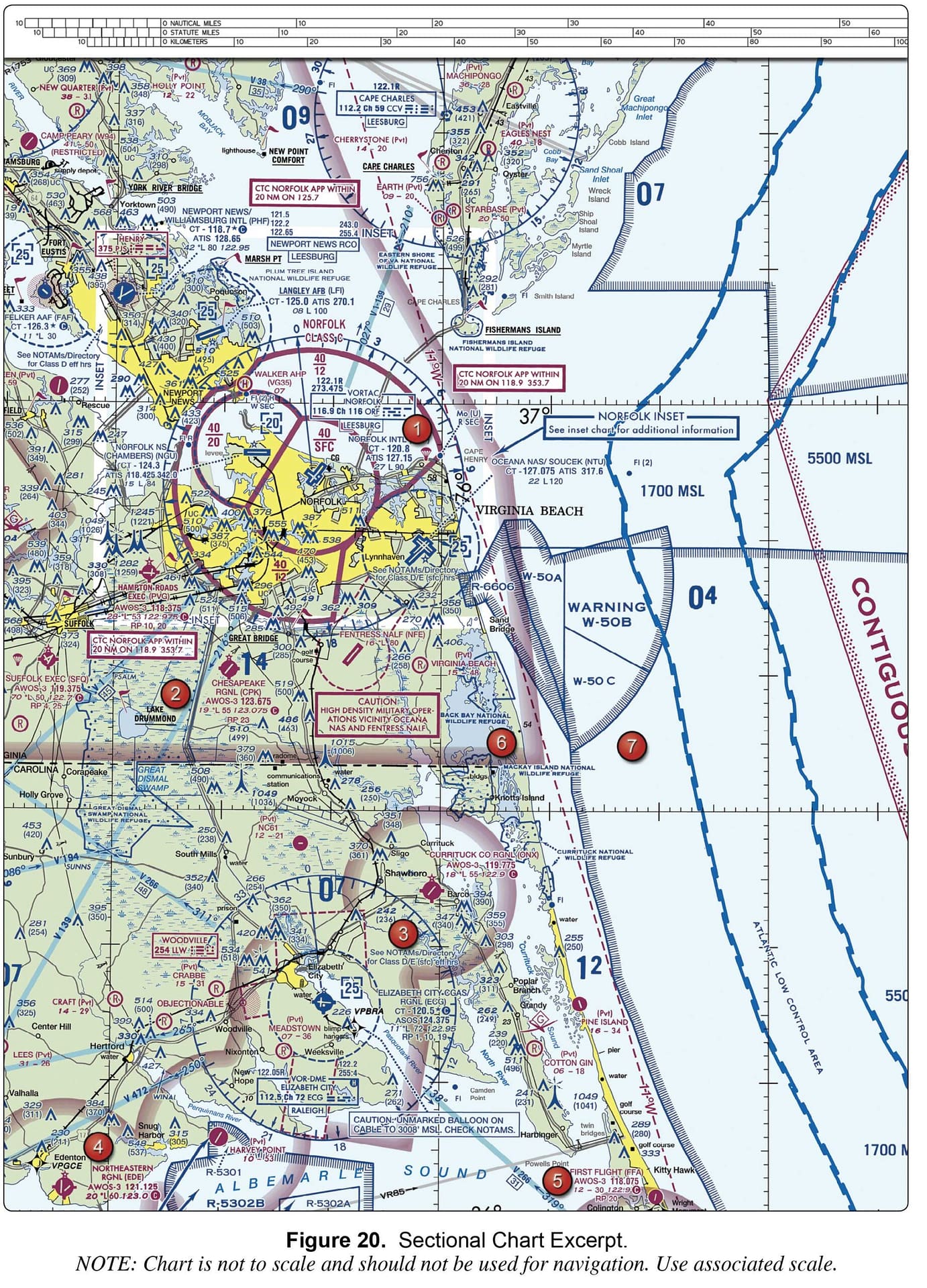
Sign Up

Sign Up to our FAA Prep for the Remote Pilot Exam. Ask questions, answer people’s questions, and connect with other UAV/Drone Pilots.

Have an account? Sign In

Have an account? Sign In Now

Sign In

Login to our social questions & Answers Engine to ask questions answer people’s questions & connect with other people.

Sign Up Here

Forgot Password?

Don't have account, Sign Up Here

Forgot Password

Lost your password? Please enter your email address. You will receive a link and will create a new password via email.

Have an account? Sign In Now

You must login to ask a question.

Forgot Password?

Need An Account, Sign Up Here

Please briefly explain why you feel this question should be reported.

Please briefly explain why you feel this answer should be reported.

Please briefly explain why you feel this user should be reported.

Sign InSign Up

UAV Campus | Remote Pilot FAA Exam Prep for Drones

UAV Campus | Remote Pilot FAA Exam Prep for Drones Logo UAV Campus | Remote Pilot FAA Exam Prep for Drones Logo
Search
Ask A Question

Mobile menu

Close
Ask A Question
  • Home
  • About Us
  • Blog
  • Contact Us

Understanding Airspace

Share
  • Facebook
1 Follower
28 Answers
28 Questions

Understanding Airspace

Home/Understanding Airspace
  • Recent Questions
  • Most Answered
  • Answers
  • No Answers
  • Most Visited
  • Most Voted
  • Random

UAV Campus | Remote Pilot FAA Exam Prep for Drones Latest Questions

UAV Campus
  • 0
UAV CampusAdministrator
Asked: August 3, 2024In: Understanding Airspace

Why are NOTAMs of interest to remote pilots?

  • 0

NOTAMs can activate Temporary Flight Restrictions. NOTAMs detail control tower operating times.  NOTAMs give weather forecasts.

airspacequestion
  • 1 Answer
  • 273 Views
Answer
UAV Campus
  • 0
UAV CampusAdministrator
Asked: August 3, 2024In: Understanding Airspace

Information concerning parachute jumping sites may be found in the

  • 0

NOTAMs. Chart Supplement. Graphic Notices and Supplemental Data

airspacequestion
  • 1 Answer
  • 288 Views
Answer
UAV Campus
  • 0
UAV CampusAdministrator
Asked: May 31, 2024In: Understanding Airspace

What line color and type denotes class B airspace?

  • 0

Shaded Blue Solid Magenta Solid Blue

  • 1 Answer
  • 280 Views
Answer
UAV Campus
  • 0
UAV CampusAdministrator
Asked: August 3, 2024In: Understanding Airspace

How are controlled firing areas shown on sectional charts?

  • 0

Controlled firing areas are shown by a comb blue line.  Controlled firing areas are shown by a comb magenta line. Controlled firing areas aren’t charted.

airspacequestion
  • 1 Answer
  • 257 Views
Answer
UAV Campus
  • 0
UAV CampusAdministrator
Asked: May 31, 2024In: Understanding Airspace

Why is the Mode C Veil of interest to remote pilots?

  • 0

Within the Mode C Veil, remote pilots are exempted from needing airspace authorization under 14 CFR part 107.41 The Mode C Veil is an exemption from remote ID requirements.  Traditional aircraft within the Mode C Veil are required to be ...
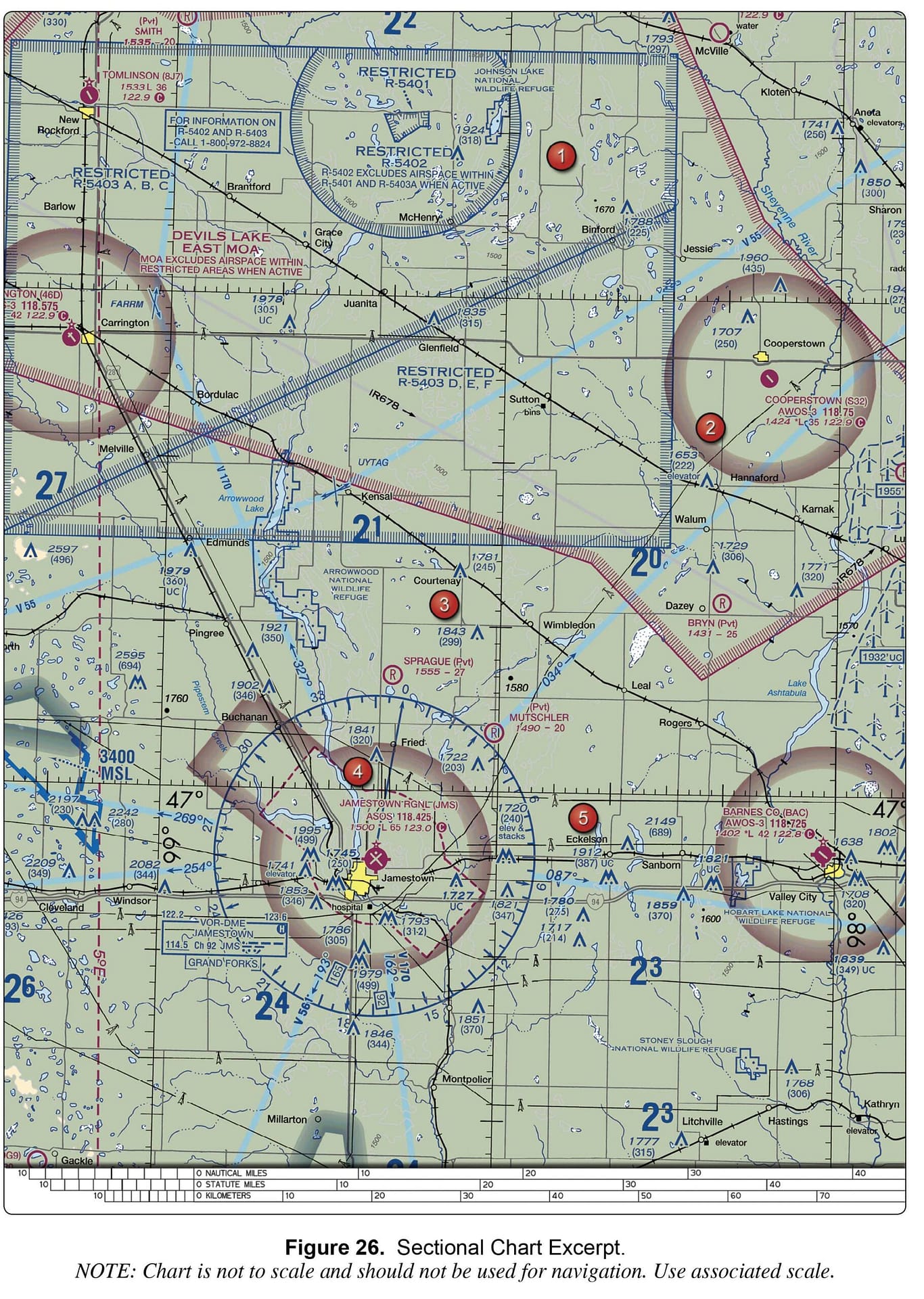
  • 1 Answer
  • 275 Views
Answer
UAV Campus
  • 0
UAV CampusAdministrator
Asked: August 3, 2024In: Understanding Airspace

What color and line type denotes Military Operating Areas on sectional charts?

  • 0

Combed Magenta lines. Shaded Blue Lines Combed Blue Lines.

airspacequestion
  • 1 Answer
  • 254 Views
Answer
UAV Campus
  • 0
UAV CampusAdministrator
Asked: May 30, 2024In: Understanding Airspace

Which airspaces are charted in AGL?

  • 0

Class B, C, and D. Class E at 700 and Class E at 1200. Class E 700, Class E 1200, and Class E 14500.

  • 1 Answer
  • 265 Views
Answer
UAV Campus
  • 0
UAV CampusAdministrator
Asked: May 31, 2024In: Understanding Airspace

What line color and type denotes class E starting at 700 feet AGL?

  • 0

Shaded Magenta Shaded Blue Dashed Magenta

  • 1 Answer
  • 264 Views
Answer
UAV Campus
  • -1
UAV CampusAdministrator
Asked: August 3, 2024In: Understanding Airspace

Where may a remote pilot obtain altitude, frequencies, and time of use for a restricted area?

  • -1

Via the top of the sectional chart.  Via the FAA’s UAS Facility Maps.  Via the FAA’s DroneZone.

airspacequestion
  • 1 Answer
  • 292 Views
Answer
UAV Campus
  • 0
UAV CampusAdministrator
Asked: May 30, 2024In: Understanding Airspace

What line color and type denotes class D airspace?

  • 0

Dashed Blue Dashed Magenta Solid Blue

  • 1 Answer
  • 283 Views
Answer

Sidebar

Ask A Question

Stats

  • Questions 315
  • Answers 314
  • Best Answers 314
  • Users 161
  • Most visited
  • UAV Campus

    What hazards to aircraft may exist in areas such as ...

    • 1 Answer
  • UAV Campus

    As temperature decreases, aircraft performance will

    • 1 Answer
  • UAV Campus

    A military air station can be identified by a rotating ...

    • 1 Answer
  • UAV Campus

    The correct method of stating 10,500 feet MSL to ATC ...

    • 1 Answer
  • UAV Campus

    You hire a German company to help you work on ...

    • 1 Answer

Categories

FAA Regulation
Understanding Weather
Understanding Airspace
UAV Loading and Performance
Navigating Charts
Airport Operations
Weather Service Dynamics
Aeronautical Decision Making (ADM)
Night Operations
Pilot Physiological Factors
Maintenance & Inspection Fundamentals
Aviation Radio Communications

Footer

UAV Campus | Remote Pilot FAA Exam Prep for Drones

UAVCampus.com provides this FAA Prep at no charge to all students and visitors. If you have a question about something on our test prep please contact us.

About Us

Legal Stuff

Help

Follow

© 2024 UAVCampus.com All Rights Reserved